
SUDBURY, ON / ACCESSWIRE / September 8, 2020 / Northern Superior Resources ("Northern Superior" or the "Company")(TSXV:SUP)(OCTQB:NSUPF) is pleased to announce that it has initiated a 5,000 metre ("m"), 14-hole core drill program on its 100% owned Lac Surprise gold property situated in one of Québec's more established and historic mining camps, Chapais-Chibougamau. This program represents Phase I of II, and is designed to test as many as three possible extensions of the Nelligan gold deposit (see IAMGOLD/Vanstar press releases, October 22, 2019) onto the Lac Surprise property. The budget for this phase of drilling is approximately $800,000. $2MM of Québec charitable flow through was raised earlier in the year (see Northern Superior press release, June 3, 2020).
The Lac Surprise property is comprised 275 mineral claims encompassing over 15,000 hectares. The Company has identified three target areas in the northeast part of the property (Figure 1).
Target Area 1
This area consists of two components, Targets 1 and 1b. Drilling in this area will test for, and hopefully better define the extent and commercial potential of the gold-bearing hydrothermal zone which extends onto the property from the neighboring Nelligan gold deposit (see Northern Superior Resources press release, October 23, 2019). This target area is particularly compelling as geologic controls observed from geophysical inversion modelling of the Nelligan gold deposit (from publicly available data) also appear to occur within this target area (see Northern Superior corporate presentation (slides 39-42), on the Company's website www.nsuperior.com).
Key controls that may have played a pivotal role in gold mineralization at the Nelligan gold deposit include:
- destruction of magnetism associated with an intrusion likely responsible for driving gold-bearing fluids into the system;
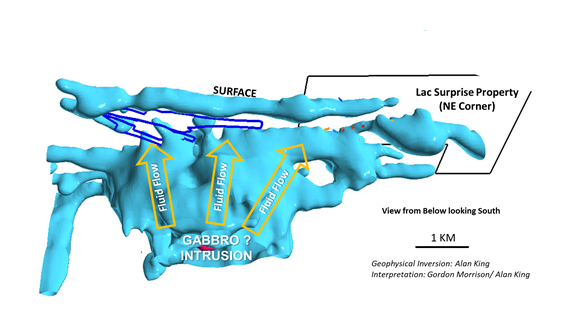
- 60° angle faults which may have accommodated and concentrated flow of gold-bearing materials (Figures 2a and 2b).
Target Area 1, encompassing an area of approximately 1,100m x 500m, will be tested with seven drill holes ranging in length between 350-450m (Figure 3). This area includes what was formally referred to as the Èpervier zone (or south limb)(discovery hole of 1.54 g/t gold over 15.15m), the north limb and the eastern part of the North trend (see Northern Superior press release August 18, 2020).
Target Area 1b may be the southwest extension of Target Area 1 (Figure 4). It is characterized by an ellipsoid shape magnetic low, bracketed by two 60° angled faults, encompassing an area of approximately 1,000m x 575m. This target will be tested by three holes, each 400m long.
Target Area 2
Target Area 2 encompasses an area of approximately 1,400 x 600m and will be tested with three drill holes ranging in length between 350m-400m. Drilling in this area will test for the western extent of the proposed "North Trend" (seeNorthern Superior press release, August 18, 2020) of the gold-bearing hydrothermal system associated with the Nelligan deposit. Target Area 2 is also the area where the Roi gold showing was discovered (see Northern Superior Resources press release, October 23, 2019)(Figure 5). This target may help us to define a possible western extension of the gold-bearing hydrothermal system associated with the Nelligan gold deposit. Alternatively, or in addition to defining the western extension of the Nelligan system, as a porphyry was intersected in connection with the Roi gold showing a very different style of mineralization may be encountered.
Target Area 3
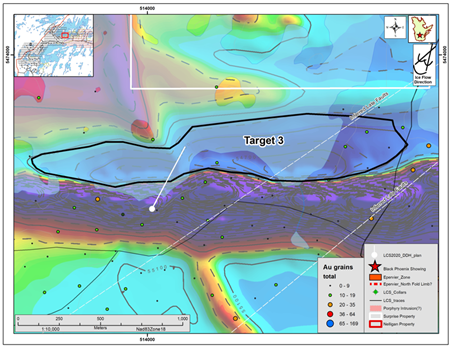
Target Area 3 encompasses an area of approximately 2,280m x 350m and will be tested with one 500m drill hole. Drilling in this area will test a prominent, elongated magnetic low abutting a ridge of highly magnetic, iron-bearing volcanics for gold (Figure 6). The geophysical signature of prominent north-northwest to south-southeast dyke is destroyed as it passes through this magnetic low. This has the potential to be an ideal setting for encountering a gold-bearing altered, highly silicified material.
Dr. T.F. Morris, President and CEO states: "The geophysical inversion modelling of the Nelligan gold deposit provided Northern Superior with a great deal additional information about the Lac Surprise property. Geophysical features identified from this modelling associated with the various Nelligan gold zones on the Lac Surprise property, are most encouraging for potential discovery of similar gold zones on Lac Suprise. We look forward to sharing the results of this program with our shareholders as they become available."
Qualified Person
Thomas F. Morris (PhD., FGAC, P.Geo., ICD.D.) is a Qualified Person ("QP") within the meaning of National Instrument 43-101. Dr. Morris has reviewed, and approved information disclosed in this press release. Michael Leblanc, who is also a Qualified Person ("QP") will be overseeing the core drill program.
Note to readers: Mineralization hosted on adjacent and/or nearby properties is not necessarily indicative of mineralization hosted on the Company's property.
About Northern Superior Resources Inc.
The Lac Surprise gold property is one of three key mineral properties 100% owned by Northern Superior Resources. The other two properties (TPK and Croteau Est) also represent regional scale exploration opportunities (see Northern Superior Corporate Presentation, www.nsuperior.com).
Northern Superior's Primary Ontario Based Projects
The TPK property is located in northwestern Ontario and is large (20kms x 30kms), containing two regional scale mineralized systems. The first system is primarily gold bearing, stretching 35kms across the Big Dam and New Growth areas of the property. The Big Dam area contains the largest gold grain-in-till dispersal aprons in North America stretching 6kms by 11kms, with as many as 1262 gold grains most of which are pristine (92%). Embedded within this apron are numerous high-grade gold mineralized boulders assaying as high as 94 g/t gold. A discovery hole of 25.87 g/t gold over 13.45m has already been intersected. The second system within the Annex area of the property is defined by a gold grain-in-till dispersal corridor 3.5kms x 13.5kms wide with gold grain counts as high as 1263, mostly pristine in shape. Embedded within this corridor are boulders assaying as high as 727g/t gold, 111g/t silver and 4.05% copper.
A drill program for the Big Dam and Annex areas of the property has been developed and ready to be initiated as soon as First Nations concerns associated with COVID-19 are at an acceptable level. The program is fully funded with a budget of $3.7million. This property is 100% Northern Superior's and is operated under an Ealy Exploration Benefits Agreement with Neskantaga First Nation.
The Croteau Est property is located within the prolific Chapais- Chibougamou gold camp of Québec and is large (30kms x 15kms). The property has a 43-101 compliant gold resource defined and several gold showings discovered across the property. The resource is defined as consisting of 11.6 million tonnes, grade 1.7g/t gold, yielding 640,000 ounces of gold. Assays associated with this deposit includes intersections of: 11.06 g/t gold over 9.10m including 43.75 g/t gold over 2.00m, 61.24 g/t gold over 5.95 m including 705 g/t gold over 0.5 m, 7.50 g/t gold over 7.95m including 56.40 g/t gold over 1.00m, 1.99 g/t gold over 34.65m including 9.46 g/t gold over 2m). The resource is defined from only 64, shallow holes most of which are only 350m deep. The system is open along strike in both directions and at depth. A core drill program and budget has been set for this project to expand the resource and test several of the showings.
Northern Superior is a reporting issuer in British Columbia, Alberta, Ontario and Québec, and trades on the TSX Venture Exchange under the symbol SUP, and the OTCQB Venture Market under the symbol NSUPF.
For Further Information
Please refer to Northern Superior news available on the Company's website (www.nsuperior.com) and on SEDAR (www.sedar.com) or contact:
Thomas F. Morris P.Geo., PhD., FGAC
President and CEO
Tel: (705) 525 ‐0992
Fax: (705) 525 ‐7701
e‐mail: info@nsuperior.com
Cautionary Note Regarding Forward-Looking Statements
This Press Release contains forward-looking statements that involve risks and uncertainties, which may cause actual results to differ materially from the statements made. When used in this document, the words "may", "would", "could", "will", "intend", "plan", "anticipate", "believe", "estimate", "expect" and similar expressions are intended to identify forward-looking statements. Such statements reflect our current views with respect to future events and are subject to such risks and uncertainties. Many factors could cause our actual results to differ materially from the statements made, including those factors discussed in filings made by us with the Canadian securities regulatory authorities. Should one or more of these risks and uncertainties, such actual results of current exploration programs, the general risks associated with the mining industry, the price of gold and other metals, currency and interest rate fluctuations, increased competition and general economic and market factors, occur or should assumptions underlying the forward looking statements prove incorrect, actual results may vary materially from those described herein as intended, planned, anticipated, or expected. We do not intend and do not assume any obligation to update these forward-looking statements, except as required by law. Shareholders are cautioned not to put undue reliance on such forward-looking statements.
Neither the TSX Venture Exchange nor its Regulation Services Provider (as that term is defined in the policies of the TSX Venture Exchange) accepts responsibility for the adequacy or accuracy of this release.
Figure 1. Drill target areas, Lac Surprise drill program.
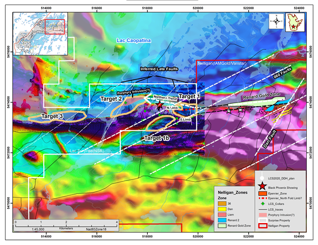
Figure 2a. Geophysical inversion model illustrating the destruction of magnetite and association of 60° angle faults to the various gold zones associated with the Nelligan deposit. The same attributes have been identified on the Northeastern part of the Lac Surprise property. Coincidently, a series of drill holes completed in 2019 defined the extension of a gold-bearing hydrothermal system from the Nelligan deposit onto the Lac Surprise property, including an intersection of 1.54g/t gold over 15.54m (LCS-19-008, see text for details).
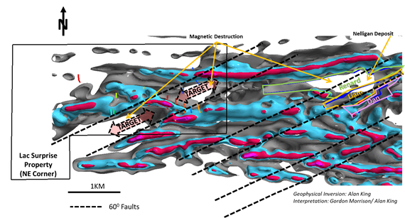
Figure 2b. Geophysical inversion model looking at the system from below and to the south. The intrusion (possibly gabbro) that is driving the system is clearly illustrated and extends under the Lac Surprise property. Magnetic destruction observed with the Nelligan gold deposit and also observed on Lac Surprise (Figure 1a) is associated with this intrusion.
Note: Collar locations and trace directions illustrated in the following set of diagrams may vary for each area depending on site conditions and drill core observations. For additional information regarding each target location the reader is encouraged to review the Company's Corporate presentation on its website (www.nsuperior.com).
Figure 3. Drill target plan, Target Area 1.
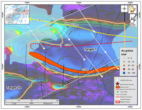
Figure 4. Drill target plan, Target Area 1b.
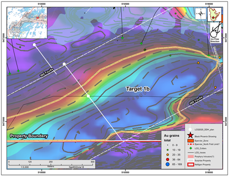
Figure 5. Drill target plan, Target Area 2.
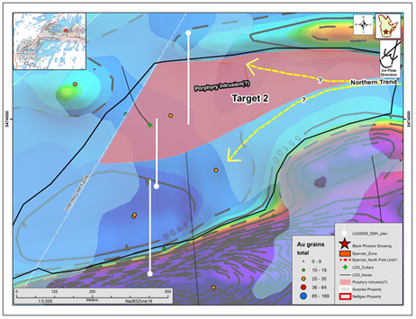
Figure 6. Drill target plan, Target Area 3.
SOURCE: Northern Superior Resources
View source version on accesswire.com:
https://www.accesswire.com/604907/Northern-Superior-Initiates-Core-Drill-Program-to-Test-Potential-Extensions-of-the-Nelligan-Gold-Project-onto-the-Lac-Surprise-Gold-Property-West-Central-Qubec
